With grant funds from the National Science Foundation, researchers at the University of Louisiana at Lafayette will begin a large-scale interdisciplinary study of water usage and management next month.
"The NSF funds cutting-edge research with the potential for global impact. That's true of this grant, too, but we'll also be doing work that can make a difference close to home," said Dr. David Borrok, director of the School of Geosciences and the grant's principal investigator.
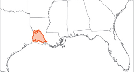
UL Lafayette will receive $483,914 for a three-year project that will focus on the Chicot Aquifer and its associated watershed areas in southwest Louisiana. The aquifer, which spans about 9,000 square miles, collects and supplies groundwater for 15 parishes: Acadia, Allen, Beauregard, Calcasieu, Cameron, Evangeline, Iberia, Jefferson Davis, Lafayette, Rapides, St. Landry, St. Martin, St. Mary, Vermilion and Vernon.
Dr. Whitney Broussard, a research scientist with the University’s Institute for Coastal Ecology and Engineering, said the Chicot Aquifer is one of the few natural phenomena that span all of Southwest Louisiana.
“Anyone who has spent time in the piney woods, the Cajun Prairie, or the Chenier Plain understands the value of the aquifer and fresh water. We use it for rice, crawfish, timber, oil, and gas production, industrial manufacturing, navigation, and recreation. This precious resource is the defining element in our low-lying coastal and wetland habitats,” Broussard said. said.
“Our challenge for the coming century will be to adapt to changing rainfall patterns, and to balance groundwater and surface water supplies with smart, efficient water use management practices. These are big questions, and big challenges that have to be addressed on a regional scale. Industry in Lake Charles can affect rice production in Acadia Parish, and vice versa. We are all in this together."
Borrok said research and governmental policy about water usage have been focused on the Southwest, where there's not enough water to go around.
"Here in Louisiana, we have different concerns. Instead of an overall lack of water, we experience seasonal droughts and flooding, as well as extreme events, such as hurricanes. So, we look for strategies to divert surface water when we have too much of it,” he said. "Meanwhile, we're still using too much groundwater. We're pumping water out of the Chicot Aquifer faster than nature can replenish it."
In southwest Louisiana, the agricultural industry, relies on water.
"Part of the research will be to survey farmers and other water users, so we can find out how they are making decisions. When and why are they using groundwater, instead of surface water?" Borrok said.
The project will also expand Louisiana's climate record. "We have about 100 years of recorded information, from just a handful of sites, about rainfall in the region. We'd like to have more information to base management decisions."
To do that, Borrok will turn to Dr. Brian Schubert, an assistant professor in UL Lafayette's School of Geosciences who uses geochemistry to unlock the climate record from ancient trees.
Another research goal is to create a digital tool, using geographic information systems, to help guide water management decisions.
Other faculty will collaborate with Borrok, including the co-principal investigators for the grant: Broussard, who is co-director of the Coastal Community Resilience Studio; Dr. JoAnne DeRouen, a professor of sociology; Dr. Emad Habib, a hydrologist and professor of civil engineering; and Dr. Durga Poudel, who has expertise in soil and water quality associated with agricultural systems.
